Search results for: photography features north dakota driving guide theodore roosevelt national park
About 3 filtered results
by Jill Waterman · Posted
Numerically speaking, the New England road map is as straightforward as it gets, which makes it a great starting point for a travel excursion. Highway numbers are ordered from East to West, so the lowest numbers—such as historic Route 1—are located farthest east. North/South highways tend to have odd number designations, such as the heavily traveled I-95, whereas East/West routes are assigned even numbers. East/West roads also tend to be numbered from north to south, with the lowest numbers located further north—such as secluded Route 2 from

by Jill Waterman · Posted
While South Dakota is officially known as the Mount Rushmore State, its status as the Land of Infinite Variety might prove even more enticing from a photographic point of view. The hodgepodge of scenic wonders contained in this sparsely populated state spans rolling prairie grasslands, rugged Black Hill forests, sparkling underground caves, and otherworldly Badland buttes, much of which is protected through America’s state or federal system of National Parks, Monuments and Forests.
Photographs © Chad
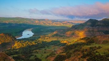
by Jill Waterman · Posted
The roughrider state of North Dakota marks the geographic center of the North American continent, commemorated by a stone obelisk in the small town of Rugby. The state’s nickname pays homage to its close association to Theodore Roosevelt, whose experiences as a North Dakota cowboy at Elkhorn Ranch had an indelible influence on his future experiences and career—from his reputation as a Spanish-American War hero to his landmark conservation efforts as the 26th President of the United States. With this history as a backdrop, we investigate the